One of the Best Things About Living Here Is You Can Pick a Direction and Within 20 Minutes You’re on a Road That’ll Take Your Breath Away
I’ve lived in Colorado Springs for over twenty years. Worked for Delta Airlines, traveled to just about every major city in this country, and I chose this place on purpose. Head west from almost anywhere in the Springs and inside of twenty minutes you’re climbing into the mountains on a road that makes you forget whatever was bugging you that morning.
Most people visit Garden of the Gods, take a selfie, and head home. But the scenic drives around this city are where the real magic is. Some routes have been here since the gold rush. Some are paved highways with guardrails. Others are dirt forest service roads where you won’t see another car for an hour.
These are the drives I actually take — in a truck, on my KTM 690 enduro, and sometimes in an RV. Here’s what to expect and which ones to prioritize.
Highway 67 to Cripple Creek via Woodland Park
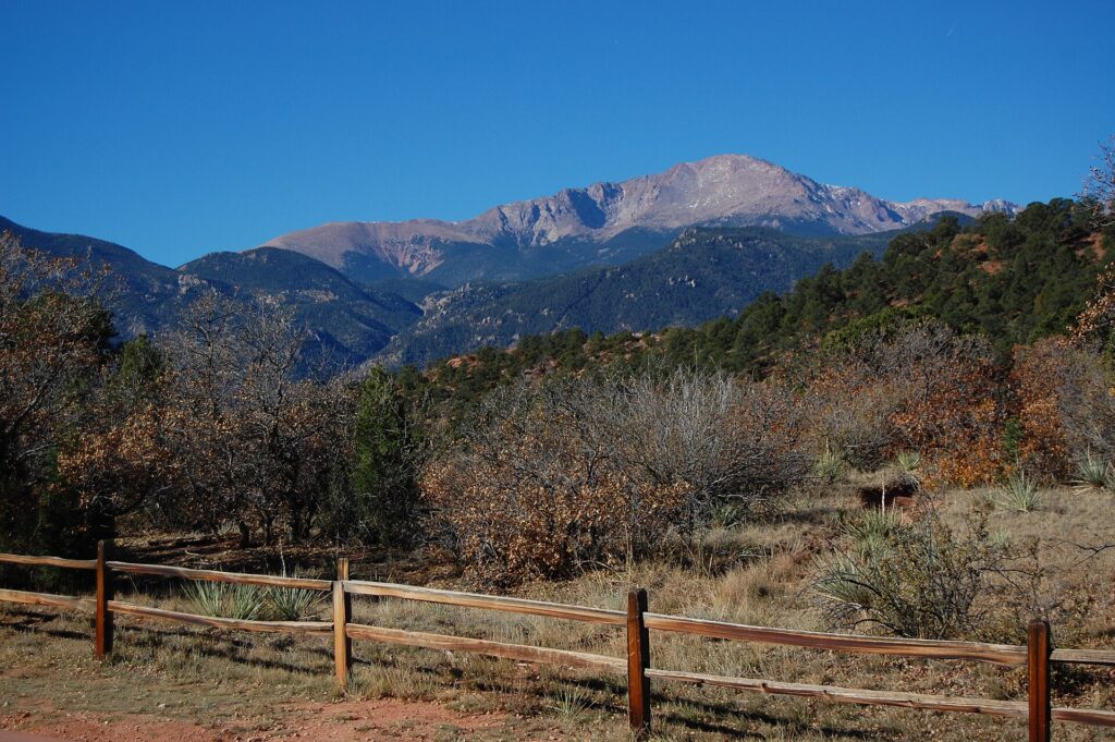
This is probably my single favorite drive from Colorado Springs, and I make it regularly. You head west on Highway 24 through Manitou Springs, climb up through Ute Pass into Woodland Park, and then turn south on Highway 67 toward Cripple Creek. The whole thing is about 45 minutes each way, and every minute of it is beautiful.
Highway 67 south of Woodland Park is the star — a two-lane highway winding through thick stands of aspen and pine, with meadows opening up on both sides. In summer it’s a deep green tunnel with wildflowers. But in fall — specifically late September — this road is absolutely unreal. The aspens turn gold and orange for miles, and on a clear day with blue sky behind them, it’s the best fall color drive in the Pikes Peak region. No question.
Once you reach Cripple Creek, you’ve got a historic gold mining town with casinos, restaurants, and the narrow gauge railroad over to Victor. But honestly, the drive itself is the main attraction.
What You Should Know
- Distance: About 45 miles each way from central Colorado Springs
- Road type: Paved highway the entire way — RV-friendly
- Best time: Late September for fall colors, but beautiful year-round
- Plan for: 2-3 hours round trip, half a day if you stop in Cripple Creek
- Loop back through Victor and Phantom Canyon Road for a full-day adventure (more below)
Gold Camp Road
Gold Camp Road is an old narrow gauge railroad bed — the Colorado Springs and Cripple Creek District Railway ran along this route during the gold rush. When the railroad shut down, they turned the railbed into a road, and you can still drive through the old railroad tunnels.
The road starts on the west side near North Cheyenne Canyon Park and climbs toward Victor and Cripple Creek. The lower section — the part with the tunnels — is the most scenic. You’re on a narrow dirt road carved into the mountainside with views down into the canyon. One tunnel collapsed years ago, so you can’t drive the full route through anymore, but what’s left is absolutely worth it.
You’re literally driving where steam engines ran over a hundred years ago. The views of the Springs from up on that road are fantastic, especially in the late afternoon light.
What You Should Know
- Road type: Unpaved, hard-packed dirt, narrow in spots
- Vehicle: A car can handle the lower section carefully, but a truck or SUV is better. Not for RVs
- Tunnel 3 is closed — the road is split into upper and lower sections
- Time: About an hour for an out-and-back on the lower section
- Connects to the High Drive route through North Cheyenne Canyon (see below)
Pikes Peak Highway
Pikes Peak is the most famous mountain in Colorado, and the highway to the top is one of the most dramatic drives you’ll ever do. You start at around 7,400 feet in Cascade and climb to 14,115 feet on a fully paved road with switchbacks, alpine meadows, and views that stretch into four states on a clear day.
I’ll be straight — I don’t drive it every weekend. But if you’ve never done it, or you’re bringing visitors, it’s a must. There are pull-offs and viewpoints the whole way up, and the summit visitor center serves the famous Pikes Peak donuts. Legitimately good.
What I love is how fast the landscape changes — pine forest to alpine tundra to bare rock above treeline in about 45 minutes. By the time you’re above 12,000 feet, you’re looking down at the world.
What You Should Know
- Distance: 19 miles from the gate to the summit
- Cost: There’s an entrance fee — check the current rate, it changes seasonally
- Altitude: 14,115 feet at the top — the air is thin, take it easy
- Time: 2-3 hours round trip including stops
- Best tip: Go early morning before clouds build. You don’t want to be above treeline when lightning starts
Highway 24 Through Ute Pass to Divide
Highway 24 west through Ute Pass is the gateway to everything on the west side. It’s how you get to Woodland Park, Divide, Cripple Creek, and eventually Buena Vista and Leadville. But the drive itself is genuinely scenic — not just a way to get somewhere.
You pick it up in Manitou Springs and immediately start climbing. The road follows Fountain Creek up through a canyon, and within ten minutes you’re in the mountains. Woodland Park is about 20 minutes up at around 8,500 feet. Keep going another 15 minutes and you hit Divide, where Highway 67 branches south to Cripple Creek.
It’s the warm-up act for so many other adventures, but on a clear morning with the sun coming through the pines, it’s a legit scenic drive on its own merit.
What You Should Know
- Road type: Four-lane highway — easy drive, any vehicle
- Time: About 30 minutes to Divide from Colorado Springs
- Stop in Woodland Park for coffee or lunch — it’s a great little mountain town
- This is the starting point for the Highway 67 drive to Cripple Creek, Rampart Range Road access, and routes further west
Rampart Range Road
This one is personal for me. Rampart Range Road is a forest service road — FR 300 — that runs along the top of the Rampart Range, the first major ridge west of Colorado Springs. It’s about 20 miles of dirt road along the ridgeline with panoramic views of the entire Front Range, and I camp up there regularly.
You’re sitting on a ridge at around 9,000 feet looking down at the city, the plains stretching east to Kansas, and on a clear day you can see the Sangre de Cristos to the south. I’ve sat in my camp chair up there at sunset more times than I can count, and it hits different every time.
This isn’t a paved scenic highway — it’s a real forest road with rocks, washboard, and mud after rain. I’ve ridden it on my KTM 690 enduro and driven it in a truck. Don’t bring a low-clearance car or a big RV up here.
What You Should Know
- Road type: Unpaved forest service road — high clearance recommended, 4WD preferred
- Vehicle: Truck, SUV, or adventure motorcycle. Not for sedans or large RVs
- Access: South end near Garden of the Gods, north end near Woodland Park
- Time: Allow 2-3 hours minimum, more if you stop to camp or hike
- Dispersed camping: Free camping along the entire road — National Forest land
- Seasonal closure — typically closed in winter and muddy spring. Check conditions before heading up
Highway 115 to Canon City and Royal Gorge
Head south on Highway 115 and you get a completely different vibe from the mountain drives to the west. This road runs along the eastern base of the Front Range toward Canon City — high desert, red rock, open grasslands with the mountains rising to the west.
Once you reach Canon City, the Royal Gorge Bridge spans a 1,000-foot deep canyon carved by the Arkansas River. The area around the gorge is impressive, and the Arkansas River through this stretch is popular for rafting with several outfitters in town. You can be at Royal Gorge in about an hour from the Springs.
What You Should Know
- Distance: About 45 miles to Canon City, another 10 to Royal Gorge
- Road type: Paved highway — any vehicle, RV-friendly
- Time: About an hour each way, half-day trip with stops
- Combine it with: A return trip through Phantom Canyon Road (if your vehicle can handle it) for a great loop
High Drive Through North Cheyenne Canyon
High Drive might be the most underappreciated scenic drive in the entire Colorado Springs area. It’s a narrow, cliffside road along the top of North Cheyenne Canyon — genuinely jaw-dropping for a road that’s fifteen minutes from downtown.
You access it through North Cheyenne Canyon Park, which is free and one of the west side’s best-kept secrets. High Drive climbs along the canyon wall on a one-lane dirt road with serious drop-offs on one side and rock walls on the other. Not dangerous if you take it slow, but definitely exciting.
This connects into Gold Camp Road, so you can combine the two into one loop through the west side mountains. Grab coffee, head into the canyon, and spend a couple hours on historic mountain roads without ever getting on a highway.
What You Should Know
- Road type: Narrow, unpaved, one lane in spots — with drop-offs
- Vehicle: Cars can do it carefully, but SUV or truck is better. Not for RVs or anything wide
- Cost: Free — North Cheyenne Canyon Park has no entrance fee
- Time: About 45 minutes for the drive, plus time to stop and stare
- Combine with: Gold Camp Road for a 2-3 hour loop through the west side mountains
Phantom Canyon Road — Victor to Canon City
Phantom Canyon Road runs from Victor (just south of Cripple Creek) down through a deep canyon to Canon City, following the old railbed of the Florence and Cripple Creek Railroad. Like Gold Camp Road, you’re driving where trains used to run — through tunnels, along canyon walls, crossing old bridges.
It’s about 30 miles of unpaved mountain road with towering rock walls, a creek alongside, old railroad infrastructure, and almost nobody else around. It feels remote in a way that’s hard to find this close to a city of half a million people.
Here’s my favorite loop: Highway 24 to Woodland Park, Highway 67 south to Cripple Creek, through Victor, down Phantom Canyon to Canon City, and back on Highway 115. Five or six hours with stops — one of the best day trips you can do from Colorado Springs.
What You Should Know
- Road type: Unpaved — rough, narrow, steep in spots
- Vehicle: High clearance recommended. Not for RVs or low-clearance vehicles
- Time: About 2 hours for the Phantom Canyon section alone
- Check conditions first — impassable after heavy rain or snow
- Gas up before you go. No services, no cell signal in parts of the canyon
Best Time for Scenic Drives Near Colorado Springs
You can do these drives year-round (well, except the dirt roads that close in winter), but some seasons are better than others.
Fall is king. Late September through mid-October is when the aspens turn, and the drives along Highway 67, Rampart Range Road, and through the mountain passes are at their absolute peak. The fall colors along the Highway 67 corridor between Woodland Park and Cripple Creek are the best I’ve seen anywhere in the Pikes Peak region. If you only visit Colorado Springs once, come in late September.
Summer mornings are perfect. June through August is beautiful, but afternoon thunderstorms roll in almost daily between 1:00 and 4:00 PM. Start early — leave by 7:00 or 8:00 AM and be heading back by early afternoon. Especially important for Pikes Peak and higher-elevation dirt roads.
Spring is muddy. March through May, the unpaved roads may be closed or impassable. Stick to paved routes unless you’ve checked conditions.
Winter is beautiful but limited. Pikes Peak Highway closes, dirt roads are snowed in, but Highway 24 and Highway 67 are gorgeous with snow on the peaks. Watch for ice.
Tips for the Road
A few things I’ve learned from twenty-plus years of driving these routes:
- Gas up before you leave town. Once you’re past Woodland Park heading south on Highway 67, or dropping into Phantom Canyon, there’s nothing. You don’t want to be watching your fuel gauge on a mountain road with no cell service
- Altitude affects your vehicle. Colorado Springs is at 6,035 feet, and some drives take you above 9,000 or even 14,000 feet. Your engine loses power at altitude — that’s normal. If your car is struggling on steep grades, pull over and let it cool
- Check road conditions for dirt roads. Pike National Forest posts conditions online. Don’t assume because it’s July that every dirt road is open — rain and washouts happen
- Bring water and layers. Temperature can drop 20-30 degrees between town and a 9,000-foot ridge. Hydration matters more at elevation than you think
- Watch for wildlife. Deer, elk, bighorn sheep — I’ve seen them all on these roads, especially at dawn and dusk
- Tell someone where you’re going if you’re heading onto unpaved roads. Cell service disappears fast on Phantom Canyon, Gold Camp Road, and Rampart Range Road
Get Out There
Paved mountain highways, historic railroad roads, cliffside forest routes, backcountry dirt roads — all within 30 minutes of a Costco and a good cup of coffee. That combination is hard to beat.
Start with the Highway 67 drive to Cripple Creek — it’s paved, it’s beautiful, and it gives you a taste of what the west side has to offer. Then work your way into Gold Camp Road, High Drive, and Rampart Range Road as you get comfortable. Save Phantom Canyon for a day when you’ve got time and a vehicle that can handle it.
These roads aren’t going anywhere. But you only live once — go drive them.
About the Author: Dominic Ferrara has lived in Colorado Springs for over 20 years. After working for Delta Airlines and visiting just about every major city in the United States, he chose Colorado Springs for its scenery, sunshine, and outdoor lifestyle. He lives on the west side near Ute Valley Park, where he e-bikes, camps, and explores the mountains regularly. His recommendations come from two decades of eating, hiking, and living here — not from a weekend visit.
More Colorado Springs Guides
- Red Rock Canyon Open Space in Colorado Springs: Hiking Trails, Scenic Views & Visitor Information – A Complete Guide to Exploring This Natural Gem
- Royal Gorge: Is It Worth the Trip? A Local’s Honest Review
- Pikes Peak: Drive It, Hike It, or Take the Train — A Local’s Breakdown
